HOW TO
Convert a TIN model from CAD data to a DEM in ArcGIS Pro
Summary
Triangulated irregular networks (TINs) are surface models used to represent complex terrains or irregular surfaces in 3D modeling. TIN models are compatible with CAD file formats and can be added to a map in ArcGIS Pro using the CAD To Geodatabase tool. This method creates a feature dataset from a geodatabase, which allows the conversion of a TIN model to a digital elevation model (DEM) for visualization and spatial analysis.
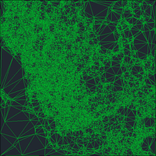
This article provides the workflow to convert a TIN model from CAD data to a DEM in ArcGIS Pro. The image below shows the TIN model as CAD data for conversion to a DEM.
Procedure
- Open the project in ArcGIS Pro.
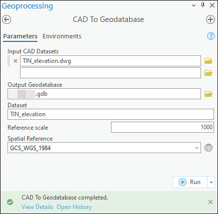
- Convert the CAD data to a geodatabase feature dataset. Refer to How To: Convert CAD data to GIS data in ArcGIS Pro for instructions.
- Add the output feature dataset in Step 2 to the map. Refer to ArcGIS Pro: Browse to data to add to a map or scene for instructions.
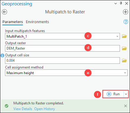
- Convert the multipatch feature class to a raster dataset using the Multipatch to Raster tool.
- On the Analysis tab, in the Geoprocessing group, click Tools.
- In the Geoprocessing pane, search for and click Multipatch to Raster (Conversion Tools).
- In the Multipatch to Raster pane, for Input multipatch features, select the multipatch feature layer from the drop-down list. In this example, the multipatch feature layer named MultiPatch_1 is selected.
- For Output raster, specify a location and name for the output raster dataset.
- For Cell assignment method, select the preferred method to use when more than one z-value is detected at the cell center. Refer to ArcGIS Pro: Parameters for more information. In this example, Maximum height is selected.
- Click Run.
Note:
Create a layout to share the DEM raster layer as a printed map, poster, or PDF file. Refer to ArcGIS Pro: Make a layout for instructions.
The image below shows the DEM converted from the TIN model in ArcGIS Pro.

Article ID: 000031817
- ArcGIS Pro 3 1
- ArcGIS Pro 3 0
- ArcGIS Pro 3 2
Get support with AI
Resolve your issue quickly with the Esri Support AI Chatbot.


Related Information
Discover more on this topic
Search for related information
Find training related to this topic
Explore ideas and give feedback
Get help from ArcGIS experts
Start chatting now