A to Z GIS | Explore this related guide, featuring updated terms and graphics and developed in coordination with Esri’s GIS Dictionary team.
Learn more about A to Z GIS
GIS Dictionary
Browse dictionary
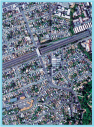
digital orthophoto quadrangle
URL copiedShare URL
[photogrammetry, standards]
Also known by the acronym DOQ. A 1-meter resolution digital orthorectified image basemap, comprising an area measuring 7.5-minutes longitude by 7.5-minutes latitude, covering the United States at a scale of 1:24,000, created from 1:40,000-scale aerial photography. Produced for, and distributed by, the United States Geological Survey (USGS). Digital orthophoto quadrangles are true photographic maps in which the effects of tilt and relief are removed by transformation or rectification. The uniform scale of a DOQ allows accurate measurement of distances.