HOW TO
Set ground control points for use in Site Scan Manager for ArcGIS
Summary
Instructions provided describe how to set ground control points (GCPs). GCPs are fixed features visible in ArcGIS Flight source images, with accurate and precise, known positions. They are used to enhance the absolute accuracy of Site Scan outputs.
Without GCPs, ArcGIS Flight outputs are solely georeferenced using the drone’s GNSS receiver and inertial sensors. While the relative accuracy within the models is high, the absolute accuracy, or where the model is located on Earth, may shift between 2-8 feet (0.6-2.4 meters).
Procedure
Setting ground control points
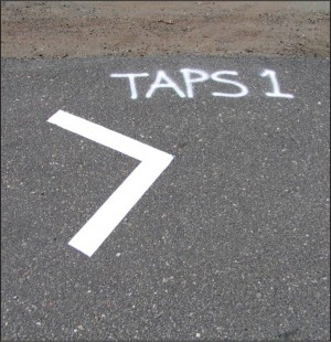
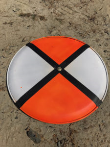
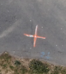
- Visibility - Easily identifiable features can be used, for example, the corner of the site trailer, the center of a manhole, or targets can either be laid or painted on the ground
- Ground control points must be immobile
- Use contrasting patterns where the surveyed location can be easily identified, such as chevrons, checkered patterns, or crosses, as shown in the images below.

Number of GCPs and layout
A minimum of three points is required. For optimal results, a minimum of five control points is recommended for a site of any size.
To maintain high accuracy throughout the processed outputs, Esri recommends using additional points for large or oddly shaped sites, or sites with many elevation changes.
For sites larger than 20 acres (eight hectares, or 80,937 m2), Esri recommends adding one GCP for each subsequent 15 acres (six hectares, or 60,702 m2).
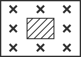
To set the first five points, visualize the five face of a dice, as shown in the next image. One point near each corner, but not on the very edge of the mapped area, and one near the center. Distribute other points evenly between the first five.
Sample GCP layouts


Active construction sites may have difficulty laying a control point near the center of the site, and it is acceptable to omit this point if unpractical. Esri recommends adding at least two additional points along the perimeter.
Measuring GCP position
- The location of the points must be obtained by a surveyor or field engineer using conventional survey methods such as total stations and survey-grade GPS, or from other reliable geographical data sources.
- ArcGIS Flight GCP processed data can only be as accurate as the original GCP position. Ideally, under 1-2 cm (0.4-0.8 in.).
- The coordinate reference system (CRS) in which the points are collected must be known, along with the units used, or the EPSG code.
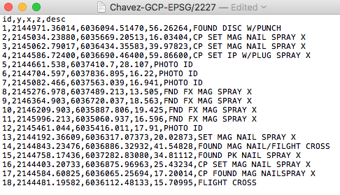
- Surveyors typically deliver a *.txt or *.csv file containing the CRS and units or EPSG code, and XYZ data for each point, along with a description.
- Assign the same CRS to your Site Scan for ArcGIS Manager project.
Article ID: 000023042
- Site Scan Manager for ArcGIS
Get support with AI
Resolve your issue quickly with the Esri Support AI Chatbot.


Related Information
Discover more on this topic
Search for related information
Find training related to this topic
Explore ideas and give feedback
Get help from ArcGIS experts
Start chatting now