HOW TO
Symbolize polygons based on the number of intersecting points
Summary
The instructions provided describe how to symbolize polygons based on the number of points that intersect or are inside the polygons.
Procedure
Before symbolizing the appropriate polygon, determine the number of points that intersect with the polygon by joining the points. This creates a new polygon feature class that has a count field representing the number of points that fall inside the polygon.
- Perform a spatial join.
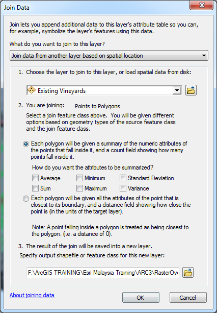
- In the Table Of Contents pane, under Layers, right-click the polygon layer, and select Joins and Relates > Join.
- In the Join Data window, under What do you want to join to this layer?, select Join data from another layer based on spatial location.
- Under Choose the layer to join to this layer, or load soatial data from disk, select the desired point layer from the drop-down list to join with the polygon layer.
- In the You are joining: Points to Polygons section, select Each polygon will be given a summary of the numeric attributes of the points that fall inside it, and a count field showing how many points that fall inside it, and specify the desired methodology for the summation.
- Specify a location for the output layer.
- Click OK.
- Export the polygon feature to a new feature class so the join becomes permanent.
- In the Table Of Contents pane, under Layers, right-click the polygon feature class. Click Data > Export Data.
- Select Yes to add the exported layer to the Table Of Contents.
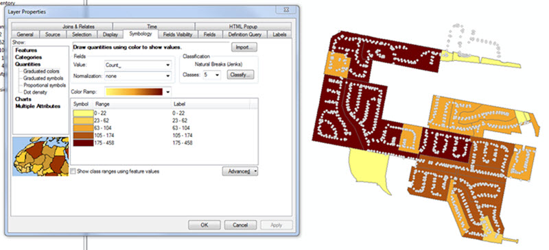
- Symbolize the new polygon feature class based on quantities using graduated colors.
- Right-click the new polygon feature class in the Table Of Contents, and click Properties.
- In the Layer Properties window, select the Symbology tab, and click Quantities > Graduated colors.
- Select the field from the Value drop-down menu (for example, Count) in which the summated values exist.
- Click OK.
Note:
If the error message, "Maximum sample size reached" is returned, follow the steps provided in Error: Maximum sample size reached. Not all records are being used to resolve the issue.
Article ID: 000012179
- ArcMap
Get support with AI
Resolve your issue quickly with the Esri Support AI Chatbot.


Related Information
Discover more on this topic
Search for related information
Find training related to this topic
Explore ideas and give feedback
Get help from ArcGIS experts
Start chatting now