HOW TO
Determine overlapping multipatch layers visibility in ArcGIS Pro
Summary
The visibility of multipatch layers is useful for urban planning and design, signal coverage, and surveillance. In many instances, a multipatch layer (building or tower) is positioned below another multipatch layer (roof or solar panel). So, merging these layers to create only one target feature before determining its visibility is essential. This article outlines the workflow to determine the visibility of multipatch layers in ArcGIS Pro.
Procedure
Note:
This workflow requires the ArcGIS Pro Advanced license. Refer to ArcGIS Pro: ArcGIS Pro license levels for more information.
- Open the ArcGIS Pro project with the multipatch layers and the observer point layer.
- Merge the overlapping multipatch layers to create a single multipatch layer using the Merge tool. For instructions to find and use the geoprocessing tool, refer to ArcGIS Pro: Find a geoprocessing tool.
- Create a polygon footprint from the merged multipatch layer using the Multipatch Footprint tool.
- Interpolate the z-values from the surface data to create a 3D feature using the Interpolate Shape tool. For Input Surface, ensure the surface data used comprises the elevation values (z-values).
Note:
Elevation can be edited on a single plane with the z-values field in the attribute table or by vertex if the output geometry attributes are irrelevant. Refer to ArcGIS Pro: Edit vertex z-values for more information.
- Create sight lines between the interpolated polygon feature and the observer points using the Construct Sight Lines tool. For Observer Height Field, specify the elevation field based on the observer points.
- Determine the visibility of the sight lines using the Line Of Sight tool. For Input Features, specify the obstruction multipatch layer, if required.
Note:
Alternatively, use the Intervisibility tool to determine the visibility of the sight lines using potential observations.
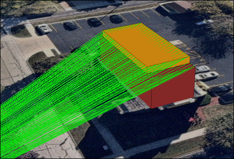
The image below shows the visibility of the sight lines from the observer point when using the Line Of Sight tool.
Article ID: 000032692
- ArcGIS Pro 3 3
- ArcGIS Pro 3 2
- ArcGIS Pro 3 4
Get support with AI
Resolve your issue quickly with the Esri Support AI Chatbot.


Related Information
Discover more on this topic
Search for related information
Find training related to this topic
Explore ideas and give feedback
Get help from ArcGIS experts
Start chatting now