HOW TO
Create a space-time cube from a multidimensional raster in ArcGIS Pro
Summary
A space-time cube is a three-dimensional representation of spatial and temporal data that is divided into cells. In ArcGIS Pro, a space-time cube can be created from a multidimensional raster using the Create Space Time Cube From Multidimensional Raster Layer tool. This method facilitates the analysis and visualization of patterns, trends, and relationships in the data across various dimensions, such as the identification of hotspots, the detection of temporal trends, and the exploration of spatial patterns over time.
The workflow provided in this article involves generating a multidimensional raster layer from a multidimensional mosaic dataset. This raster layer is then used as the input raster to generate a space-time cube, which is then displayed in 3D for better visualization and interpretation.
Procedure
- Open the project in ArcGIS Pro.
- On the View tab, in the Windows group, click Catalog Pane.
- Create and add the imagery to a mosaic dataset. Refer to ArcGIS Pro: Create a mosaic dataset for instructions.
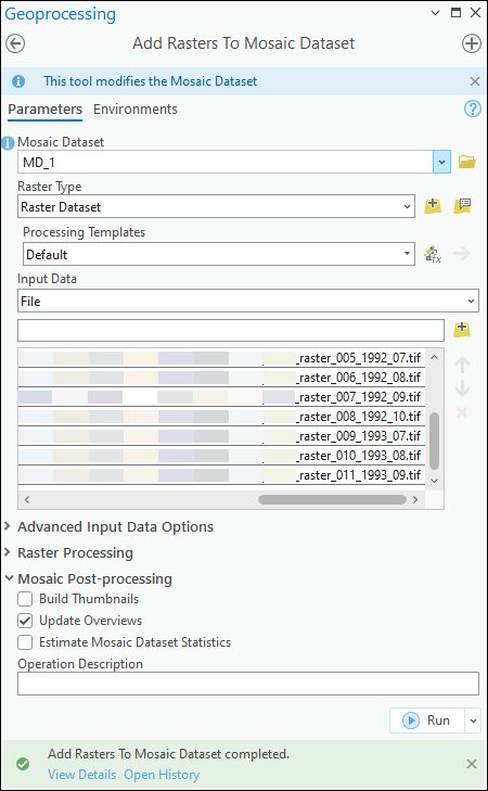
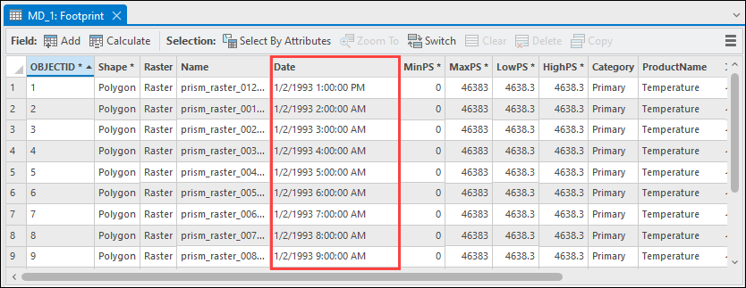
- Add a date field to the mosaic dataset attribute table and populate all columns with a valid imagery date and time. Refer to How To: Assign date and time to a mosaic dataset to visualize temporal change in ArcGIS Pro for instructions.
- Generate multidimensional metadata in the mosaic dataset using the Build Multidimensional Info tool.
- On the Analysis tab, in the Geoprocessing group, click Tools.
- In the Geoprocessing pane, search for and click Build Multidimensional Info (Multidimension Tools).
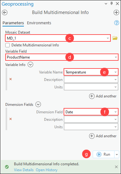
- In the Build Multidimensional Info pane, for Mosaic Dataset, select the created mosaic dataset in Step 3 from the drop-down list. In this example, the mosaic dataset named MD_1 is selected, as shown in the next image.
- For Variable Field, select the preferred field in the mosaic dataset containing the variable name from the drop-down list. Refer to ArcGIS Pro: Parameters for more information. In this example, the variable field named ProductName is selected.
- For Variable Name under Variable Info, select the variable from the drop-down list. In this example, the variable named Temperature is selected.
- For Dimension Field under Dimension Fields, select the created date field in Step 4 from the drop-down list.
- Click Run.
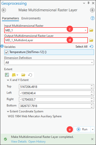
- Create a multidimensional raster layer from the multidimensional mosaic dataset using the Make Multidimensional Raster Layer tool.
- On the Analysis tab, in the Geoprocessing group, click Tools.
- In the Geoprocessing pane, search for and click Make Multidimensional Raster Layer (Multidimension Tools).
- In the Make Multidimensional Raster Layer pane, for Input Multidimensional Raster, select the mosaic dataset from the drop-down list.
- For Output Multidimensional Raster Layer, specify a name and location for the multidimensional raster layer.
- Click Run.
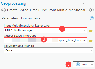
- Create a space-time cube from the multidimensional raster layer using the Create Space Time Cube From Multidimensional Raster Layer tool.
- On the Analysis tab, in the Geoprocessing group, click Tools.
- In the Geoprocessing pane, search for and click Create Space Time Cube From Multidimensional Raster Layer (Space Time Pattern Mining Tools).
- In the Create Space Time Cube From Multidimensional Raster Layer pane, for Input Multidimensional Raster Layer, select the output multidimensional raster layer in Step 6 from the drop-down list.
- For Output Space Time Cube, click Browse
 and specify a location and name for the output space-time cube.
 - Click Run.
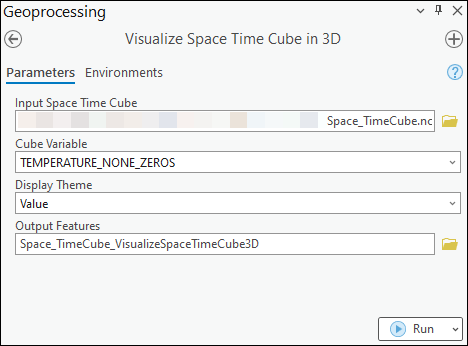
- Visualize the variables in the netCDF space-time cube in three dimensions. Refer to ArcGIS Pro: Visualize the space-time cube in 3D for instructions.
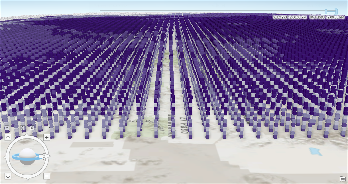
The image below shows the space-time cube created from the multidimensional raster layer in ArcGIS Pro.
Article ID: 000032218
- ArcGIS Pro 3 1
- ArcGIS Pro 3 0
- ArcGIS Pro 3 2
Get support with AI
Resolve your issue quickly with the Esri Support AI Chatbot.


Related Information
Discover more on this topic
Search for related information
Find training related to this topic
Explore ideas and give feedback
Get help from ArcGIS experts
Start chatting now