A to Z GIS | Explore this related guide, featuring updated terms and graphics and developed in coordination with Esri’s GIS Dictionary team.
Learn more about A to Z GIS
GIS Dictionary
Browse dictionary
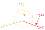
y-axis
URL copiedShare URL
[geodesy, geometry]
In a planar coordinate system, the vertical line that runs above and below (north and south of) the origin (0,0). Numbers north of the origin are positive, and numbers south of it are negative.
[geodesy]
In a spherical coordinate system, a line in the equatorial plane that passes through 90 degrees east longitude.
[geodesy, measurement]
On a chart, the vertical axis.