A to Z GIS | Explore this related guide, featuring updated terms and graphics and developed in coordination with Esri’s GIS Dictionary team.
Learn more about A to Z GIS
GIS Dictionary
Browse dictionary
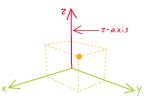
z-axis
URL copiedShare URL
[geodesy, geometry]
In a spherical coordinate system, the vertical line that runs parallel to the earth's rotation, passing through 90 degrees north latitude, and perpendicular to the equatorial plane, where it crosses the x- and y-axes at the origin (0,0,0).