A to Z GIS | Explore this related guide, featuring updated terms and graphics and developed in coordination with Esri’s GIS Dictionary team.
Learn more about A to Z GIS
GIS Dictionary
Browse dictionary
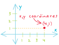
x,y coordinates
URL copiedShare URL
[coordinate systems]
A pair of values that represents the distance from an origin (0,0) along two axes, a horizontal axis (x), and a vertical axis (y). On a map, x,y coordinates are used to represent features at the location they are found on the earth's spherical surface.