A to Z GIS | Explore this related guide, featuring updated terms and graphics and developed in coordination with Esri’s GIS Dictionary team.
Learn more about A to Z GIS
GIS Dictionary
Browse dictionary
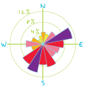
wind rose
URL copiedShare URL
[aerospace, visualization techniques]
A diagram showing, for a given place and time, how much of the time the wind blows from each direction. Wind roses have many variations, but in the typical pattern, a number of wedges (usually 8, 12, or 16) radiate from the center of a circle. The width and orientation of a wedge represent the direction from which the wind blows; the length of a wedge represents the percentage of time the wind blows from that direction. More complex wind roses use color schemes and other graphic devices to represent wind speed and related information.