A to Z GIS | Explore this related guide, featuring updated terms and graphics and developed in coordination with Esri’s GIS Dictionary team.
Learn more about A to Z GIS
GIS Dictionary
Browse dictionary
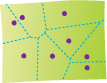
Voronoi diagram
URL copiedShare URL
[geometry]
A partition of space into areas, or cells, that surround a set of geometric objects (usually points). These cells, or polygons, must satisfy the criteria for Delaunay triangles. All locations within an area are closer to the object it surrounds than to any other object in the set. Voronoi diagrams are often used to delineate areas of influence around geographic features. Voronoi diagrams are named for the Ukrainian mathematician Georgy Feodosevich Voronyi (1868 – 1908).