A to Z GIS | Explore this related guide, featuring updated terms and graphics and developed in coordination with Esri’s GIS Dictionary team.
Learn more about A to Z GIS
GIS Dictionary
Browse dictionary
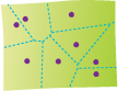
Thiessen polygon
URL copiedShare URL
[geometry]
Polygons generated from a set of sample points. Each Thiessen polygon defines an area of influence around its sample point, so that any location inside the polygon is closer to that point than any of the other sample points. Named for the American meteorologist Alfred H. Thiessen (1872 – 1956), Thiessen polygons are more commonly known as Voronoi diagrams, other than when used to analyze spatially distributed data in geophysics and meteorology.