A to Z GIS | Explore this related guide, featuring updated terms and graphics and developed in coordination with Esri’s GIS Dictionary team.
Learn more about A to Z GIS
GIS Dictionary
Browse dictionary
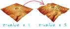
vertical exaggeration
URL copiedShare URL
[visualization techniques]
A multiplier applied uniformly to the z-values of a three-dimensional model to enhance the natural variations of its surface. Scenes may appear too flat when the range of x- and y-values is much larger than the z-values. Setting vertical exaggeration can compensate for this apparent flattening by increasing relief.