A to Z GIS | Explore this related guide, featuring updated terms and graphics and developed in coordination with Esri’s GIS Dictionary team.
Learn more about A to Z GIS
GIS Dictionary
Browse dictionary
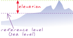
elevation
URL copiedShare URL
[geodesy, measurement]
The vertical distance of a point or object above or below a reference surface or datum (generally mean sea level). Elevation generally refers to the vertical height of land.