A to Z GIS | Explore this related guide, featuring updated terms and graphics and developed in coordination with Esri’s GIS Dictionary team.
Learn more about A to Z GIS
GIS Dictionary
Browse dictionary
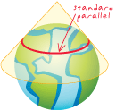
standard parallel
URL copiedShare URL
[map projections]
The line of latitude in a conic or cylindrical projection in normal aspect where the projection surface touches the globe. A tangent conic or cylindrical projection has one standard parallel, while a secant conic or cylindrical projection has two. At the standard parallel, the projection shows no distortion.