A to Z GIS | Explore this related guide, featuring updated terms and graphics and developed in coordination with Esri’s GIS Dictionary team.
Learn more about A to Z GIS
GIS Dictionary
Browse dictionary
parallel
URL copiedShare URL
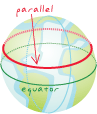
[geodesy]
An imaginary east-west line encircling the earth, parallel to the equator and connecting all points of equal latitude that can be used to define locations north or south of the equator. Also, the representation of this line on a globe or map.