A to Z GIS | Explore this related guide, featuring updated terms and graphics and developed in coordination with Esri’s GIS Dictionary team.
Learn more about A to Z GIS
GIS Dictionary
Browse dictionary
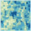
graduated color map
URL copiedShare URL
[thematic mapping]
A map on which a range of colors indicates a progression of numeric values. For example, increases in population density might be represented by the increased saturation of a single color, or temperature differences by a sequence of colors from blue to red.