A to Z GIS | Explore this related guide, featuring updated terms and graphics and developed in coordination with Esri’s GIS Dictionary team.
Learn more about A to Z GIS
GIS Dictionary
Browse dictionary
feature
URL copiedShare URL
[geodesy]
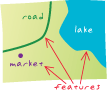
Any part of the earth's surface, or anything found on the earth's surface, that can be represented on a map. Features can represent various types of geographic entities, such as points, lines, polygons, or more complex objects like networks or surfaces. Each feature typically has associated attributes that provide additional information—such as its name, population, or elevation—and may have additional, spatial characteristics, such as geographic coordinates.