A to Z GIS | Explore this related guide, featuring updated terms and graphics and developed in coordination with Esri’s GIS Dictionary team.
Learn more about A to Z GIS
GIS Dictionary
Browse dictionary
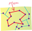
polygon
URL copiedShare URL
[geometry]
On a map, a closed shape defined by a connected sequence of x,y coordinate pairs, where the first and last coordinate pair are the same and all other pairs are unique.
[geometry]
A shape defined by one or more rings, where a ring is a path that starts and ends at the same point. If a polygon has more than one ring, the rings may be separate from one another or they may nest inside one another, but they may not overlap.