A to Z GIS | Explore this related guide, featuring updated terms and graphics and developed in coordination with Esri’s GIS Dictionary team.
Learn more about A to Z GIS
GIS Dictionary
Browse dictionary
differential correction
URL copiedShare URL
[remote sensing, standards]
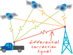
A technique for increasing the accuracy of GPS/GNSS measurements by comparing observed with known ranges or coordinates at a fixed base station and transmitting corrections to roving receivers.
[remote sensing, standards]
A method of improving the accuracy of a GPS/GNSS location using corrections broadcast from a GPS/GNSS base station.