A to Z GIS | Explore this related guide, featuring updated terms and graphics and developed in coordination with Esri’s GIS Dictionary team.
Learn more about A to Z GIS
GIS Dictionary
Browse dictionary
central meridian
URL copiedShare URL
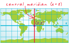
[coordinate systems]
The line of longitude that defines the center and often the x-origin of a projected coordinate system. In planar rectangular coordinate systems of limited extent, such as state plane, grid north coincides with true north at the central meridian.
[geodesy]
The geographic origin of the longitudinal x-coordinates for a map grid. Also called the longitude of origin or, less commonly, the longitude of center.