A to Z GIS | Explore this related guide, featuring updated terms and graphics and developed in coordination with Esri’s GIS Dictionary team.
Learn more about A to Z GIS
GIS Dictionary
Browse dictionary
longitude
URL copiedShare URL
[geodesy, measurement]
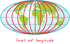
The location of a point on the earth's surface, stated as an angular measurement in degrees, minutes, and seconds east or west of the Greenwich prime meridian. All lines of longitude are great circles that intersect the equator and pass through the north and south poles.
[measurement]
The numbering system used for meridians.