A to Z GIS | Explore this related guide, featuring updated terms and graphics and developed in coordination with Esri’s GIS Dictionary team.
Learn more about A to Z GIS
GIS Dictionary
Browse dictionary
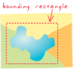
bounding rectangle
URL copiedShare URL
[cartography, map design]
A rectangle—aligned with the coordinate axes and placed on a map display—that encompasses a geographic feature, group of features, or an area of interest. It is defined by minimum and maximum coordinates in the x and y directions and is used to represent, in a general way, the location of a geographic area.