A to Z GIS | Explore this related guide, featuring updated terms and graphics and developed in coordination with Esri’s GIS Dictionary team.
Learn more about A to Z GIS
GIS Dictionary
Browse dictionary
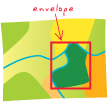
envelope
URL copiedShare URL
[measurement, geometry]
The rectangle surrounding one or more geographical features in coordinate space, determined by the minimum and maximum coordinates in the x and y directions, as well as the ranges of any z- or m-values that the features may have. An envelope can be used to filter data for analysis.