Frequently asked question
What are the flight modes available in ArcGIS Flight?
ArcGIS Flight has a variety of flight modes depending on the type of area or structure that you intend to map or model. These can be large areas, individual structures, manual inspections, or a combination of all of them. The supported flight modes include:
- Area Survey
- Crosshatch Survey
- Perimeter Scan
- Vertical
- Panorama
- Corridor Scan
- Inspection
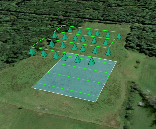
Area Survey
Area Survey flight mode follows the traditional lawn mower flight path that is found across third-party flight apps. This flight pattern is effective at mapping large areas in a quick and efficient manner. The drone is typically flown with the camera pointed straight down at the surface at a 0-degree gimbal angle (nadir).
When to use Area Survey:
- Mapping large areas with little elevation change (fields, parking lots)
- Updating a basemap
- Identifying topographic informatiion
The image below shows a the flight path (green line) for an Area Survey with camera projections indicated by the green pyramids. The area being scanned is indicated by the blue rectangle.
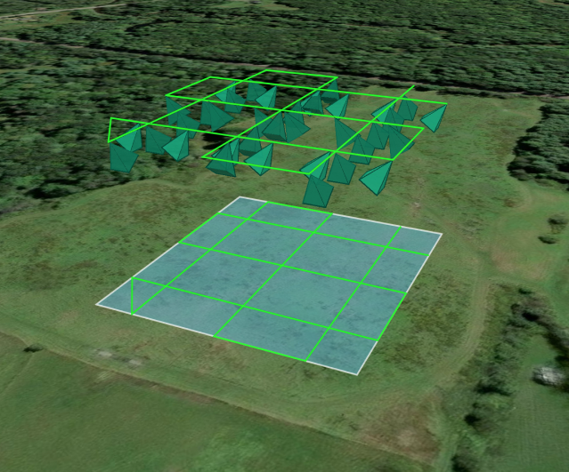
Crosshatch Survey
Crosshatch Survey flight mode is best suited for sites that have vertical features that need to be captured. This flight mode uses a crosshatched flight path so it will take double the resources (time, batteries and images taken) to complete compared to a traditional Area Survey flight. This pattern must be flown with the camera set at an angle; a camera angle set between 35 and 40 degrees delivers the best results in most cases. Due to the crosshatched pattern and the oblique gimbal angle used when flying, this flight mode will capture the features of your site from multiple perspectives you with rich data for generating point clouds or meshes. Photos from a Crosshatch Survey can be merged with an Area Survey for higher quality processing.
When to use Crosshatch Survey
- Mapping sites with many vertical features, for example, buildings or elevation
- Capturing data to generate 3D products/digital twins
The image below shows a the flight path (green line) for a Crosshatch Survey with camera projections indicated by the green pyramids. The area being scanned is indicated by the blue square.
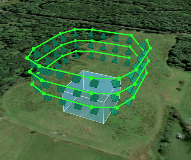
Perimeter Scan
Perimeter Scan flight mode is ideal for creating high-resolution 3D models of tall individual structures like buildings, cell towers, and spires. The drone will orbit the structure at multiple altitudes. Photos from a Perimeter Scan can be merged with an Area Survey for higher quality processing.
When to use Perimeter Scan:
- Creating high-fidelity 3D models of tall individual structures.
Considerations:
- For safety, the Minimum Flight Height should be set to higher than the top of the structure being scanned
- The Maximum Flight Height should be set to 1.5x - 2x higher than the minimum flight height
- The flight path is generated with an default Offset of 100 feet, with a minimum of 50 feet. This default minimum offset reduces the risk of colliding into vertical structures.
- Larger structures should have a larger offset, as a corner of the structure should be visible in a majority of the images
The image below shows a the flight path (green line) for a Perimeter Scan with camera projections indicated by the green pyramids. The structure being scanned is indicated by the blue cube.
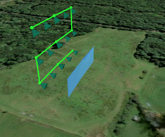
Vertical
Vertical flight mode is effective in capturing façades of vertical structures such as a building, dam, or mining site. This flight mode has additional settings that allow for angled façades, both those with a fixed or variable slope. You can merge a Vertical Scan with an Area Survey or a Crosshatch Survey to get richer 3D results.
When to use Vertical:
- Scanning a vertical face of a structure, such as a façade for building inspection
Considerations:
- Ensure the green line on the map (representing flight path) is facing the façade to be scanned
- Use the Switch Side setting to quickly swap the orientation of the flight path relative to the façade
- Change the map to 3D View for further perspective on your vertical scan's orientation
The image below shows a the flight path (green line) for a Vertical flight with camera projections indicated by the green pyramids. The façade being scanned is indicated by the blue rectangle.
Panorama
Panorama flight mode is ideal for creating a 360-degree panorama photo to capture a complete view of a job site and the surrounding area. The panorama generated will include the area directly underneath the drone.
When to use Panorama:
- Taking a panorama photo of a job site
- Tracking project progress on a regular basis from with a holistic view
- Generating marketing material for scenic regions
Considerations:
- Typically the fastest completion of the flight modes
The image below shows the coverage area (blue cone) of a Panorama flight. The drone will ascend to the user-defined flight height, and rotate (yaw) to capture imagery of the area within the cone.

Corridor Scan
Corridor Scan is suited for capturing long and narrow areas of interest. Corridor Scans can be conducted with the drone to flying directly over or next to and along side the corridor of interest.
When to use Corridor Scan:
- Capturing long and narrow areas of interest such as roads, pipelines, airport runways
- Conducting right of way inspections
Considerations:
- The Corridor Width can be adjusted to accommodate for a variety of corridor sizes. Corridors with a large with may require multiple flight legs in each direction (in a pattern akin to Area Survey) to gather full coverage
- If Fly Over Corridor is set to Yes, the drone is flown with a nadir gimbal angle
- If Fly Over Corridor is set to No, ArcGIS Flight will automatically calculate the correct gimbal angle in each flight leg to ensure complete coverage of the corridor
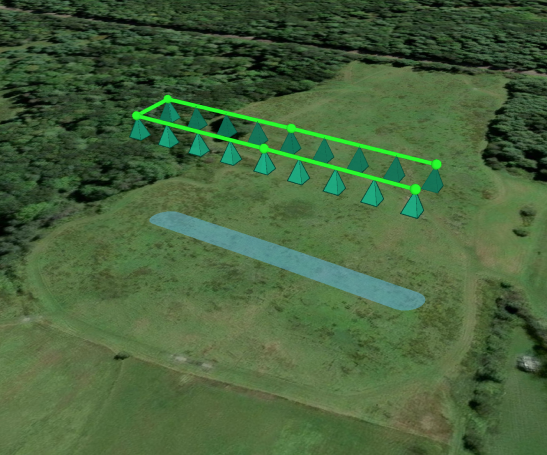
The image below shows a the flight path (green line) for a Corridor Scan with camera projections indicated by the green pyramids. The corridor of interest is indicated by the narrow blue rectangle.
Inspection
Inspection is ArcGIS Flight's manual flight mode. After takeoff, the drone will autonomously climb to the predetermined flight height where it is entirely reliant on the pilot for further movement. Inspection allows pilots to control their drone with more flexibility than a predetermined flight plan. You can manually take photos of areas of interest or you can record a video.
When to use Inspection:
- Conducting manual, intricate structure inspections
- Flying a path not similar to any of the other flight modes
- Quickly capturing point-source imagery
Article ID: 000022893
- Mobile Applications
Get support with AI
Resolve your issue quickly with the Esri Support AI Chatbot.


Discover more on this topic
Search for related information
Find training related to this topic
Explore ideas and give feedback
Get help from ArcGIS experts
Start chatting now