HOW TO
Concatenate fields in a table in ArcGIS Pro
Summary
In ArcGIS Pro, it is possible to concatenate fields in a table, and display the field attributes in a new field using the Field Calculator. Concatenating fields may be necessary to merge or summarize two or more attributes into one field.
Procedure
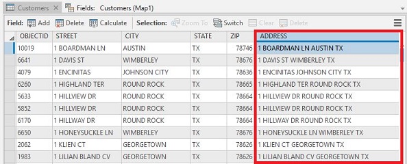
The instructions provided below describe how to concatenate two or more fields in a table, and display the combined field attributes in a new field using ArcGIS Pro. In this example, the street, city, and state fields are concatenated to display full addresses.
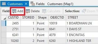
- In the Contents pane, right-click the selected layer or stand-alone table, and select the Attribute Table or Open option, depending on the data source.
- In the attribute table, click Add Field.
Note:
It is possible to use an existing field, but the output of this process overwrites the existing data in the field.
- Define the new field name and data type.
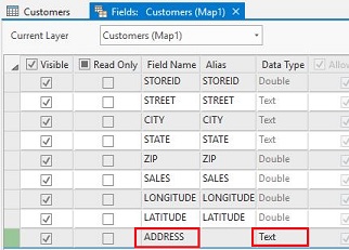
Note:
To concatenate string fields, select the text data type. Select either a short or long integer data type for number fields. For more information on the field data types, refer to the following documentation: ArcGIS field data types.
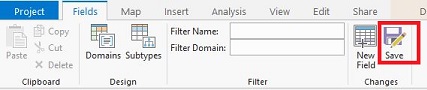
- On the Fields tab, click Save.
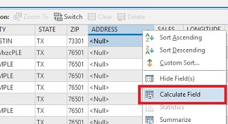
- In the attribute table, right-click the new field name, and select Calculate Field.
- Type the following expression, and replace !Field Name! with the name of each individual field to be concatenated from the Fields list:
Code:
!Field Name! + " " + !Field Name! + " " + !Field Name!
Note:
The double quotation marks (" ") with a space in between them add a space between the values that are being concatenated. If necessary, remove (" ") to eliminate the space between the field names.
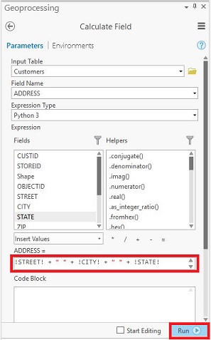
- Click Run. The fields are concatenated and displayed in the new field.
Article ID: 000018207
- ArcGIS Pro
Get support with AI
Resolve your issue quickly with the Esri Support AI Chatbot.


Related Information
Discover more on this topic
Search for related information
Find training related to this topic
Explore ideas and give feedback
Get help from ArcGIS experts
Start chatting now