ERROR
ERROR 001270: Consolidating the data failed
Error Message
When attempting to publish a feature service to ArcGIS Online, the following error message is returned:
Error:
ERROR 001270: Consolidating the data failed.
Cause
The error occurs due to one of the following reasons:
- The output geodataset is enabled to store m-values and z-values in the Environment Settings in ArcMap. When m-values and z-values are enabled in ArcMap, the geometry of features cannot change in ArcGIS Online.
- The map document contains group layers. Group layers are not supported in ArcGIS Online.
- The map document contains a corrupted feature dataset.
- The feature classes or tables contain in-memory joins. In-memory joins are not supported in an ArcGIS Online feature service.
Solution or Workaround
Depending on the cause, use one of the options below to resolve the issue.
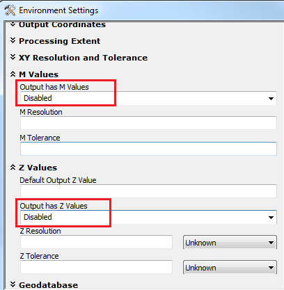
Disable m-values and z-values for the output layer in the Environment Settings before publishing
- In ArcMap, navigate to Geoprocessing > Environments > Environment Settings.
- In the Environment Settings window, expand M Values.
- From the Output has M Values drop-down list, select Disabled.
- Expand Z Values and from the Output has Z Values drop-down list, select Disabled.
- Click OK.
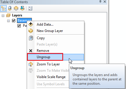
Ungroup layers from the group layers to add the contained layers to the parent layer
To ungroup the layers, right-click the group layer name, and click Ungroup.
Repair the corrupted dataset
In ArcMap, run the Check Geometry tool to identify geometry errors in the dataset. To fix the corrupted data, run the Repair Geometry tool. Refer to ArcMap: Checking and repairing geometries for more information on identifying and repairing datasets.
Make a permanent join to each feature class or joined table
Make a permanent join to each feature class or joined table by exporting the joined feature layer or table. To export the layer, right-click the layer in Table Of Contents > Data > Export Data. This creates a new feature class with all the attributes, including the joined fields.
Article ID: 000014995
- ArcMap
- ArcGIS Online
Get support with AI
Resolve your issue quickly with the Esri Support AI Chatbot.


Related Information
Discover more on this topic
Search for related information
Find training related to this topic
Explore ideas and give feedback
Get help from ArcGIS experts
Start chatting now