Frequently asked question
Why does ArcGIS Online use a deprecated spatial reference (102100) for hosted services?
ArcGIS Online uses the WGS_1984_Web_Mercator_Auxiliary_Sphere (WKID 3857) projection. However, from the REST endpoint of a hosted service, the spatial reference being used may appear as 102100 (3857). This is an expected behavior. The well-known ID (WKID) for a given spatial reference may occasionally change.
At ArcGIS version 10, the WKID for the WGS 1984 Web Mercator (Auxiliary Sphere) projection was changed from 102100 to 3857. The JSON wkid property is always the value originally assigned to a spatial reference when it was initially created. The reason behind this is to ensure backwards compatibility with older spatial data servers. This is documented in the following ArcGIS REST API help page: Geometry objects.
For ArcGIS version 10.1 and later, a new property (latestWkid) was added. latestWkid identifies the current WKID value as of a given software release, associated with the same spatial reference.
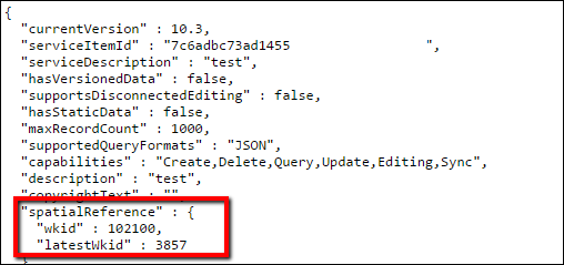
To view the wkid and latestWkid properties, request the JSON of a map layer by appending “?f=pjson” to the end of the service URL. For example:
https://sampleserver6.arcgisonline.com/arcgis/rest/services/SampleWorldCities/MapServer/0?f=pjson
The following image is an example of the wkid and latestWkid properties displayed after requesting the JSON of a map layer:
Article ID: 000013950
- ArcMap
- ArcGIS Pro
- ArcGIS Online
Get support with AI
Resolve your issue quickly with the Esri Support AI Chatbot.


Related Information
Discover more on this topic
Search for related information
Find training related to this topic
Explore ideas and give feedback
Get help from ArcGIS experts
Start chatting now