PROBLEM
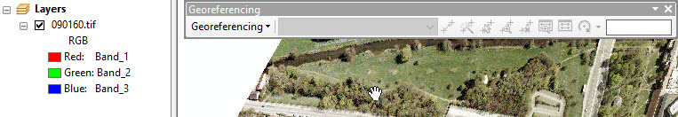
The Georeferencing toolbar is inactive or 'grayed out'
Description
All of the tools and menu options in the Georeferencing toolbar are 'grayed out' even though there is a raster layer in the data frame.
Cause
This issue can occur in any version of ArcMap. Assuming there is a raster layer in the data frame, some of the causes include:
- The raster dataset has a defined projection and is being projected on the fly. ArcMap cannot apply a double-transformation to the raster.
- The raster dataset is in an unsupported format.
- The data frame is rotated. ArcMap cannot apply a double-transformation to the raster.
- The raster was added to the data frame as a graphic object (via Insert > Picture). Graphic objects are not listed in the Table of Contents.
- The normal.mxt is corrupt.
- If using ArcGIS 9.0, the name of the coordinate system of the raster may be different from that of the data frame. This is a known issue in ArcGIS 9.0.
- Spatial Reference information for a raster can be stored in a PRJ, an AUX, a WLD, or in the image header. If any of these conditions exist, the Georeferencing toolbar is not active.
Solution or Workaround
To activate the Georeferencing toolbar, use one of the following solutions.
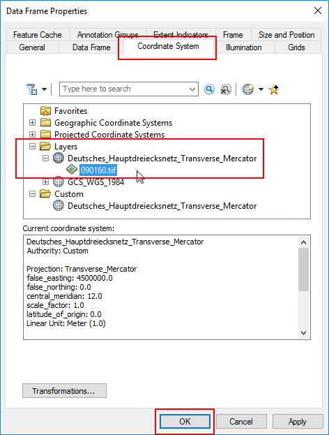
- Verify the raster coordinate system
Right-click the map and open the Data Frame Properties. Under Coordinate System, expand the Layers folder > coordinate system, click the name of the raster layer, and click OK. Or, remove any layers with differing datums from the data frame / map. Additional layers can be added to the map after the georeferencing workflows are complete.
- Set Data Frame rotation back to 0
From the data frame toolbar, change the rotation angle to 0. Then georeference the raster. If the data frame must be rotated, use the Rectify option to use a georeferenced version of the raster in the map document.
- Use the Add Data dialog
To georeference an image in ArcMap, the image must be added as data through the Add Data dialog. Images inserted into the map as pictures cannot be georeferenced because pictures are read as graphic objects and not GIS data. Graphic objects cannot be related to actual data in real-world coordinate space.
- Normal.mxt
Navigate to the Normal.mxt and rename it. Restart ArcMap. Please note that this removes any changes or customization to the ArcMap interface, but may grant access to the Georeferencing toolbar.
- Wrong Name
There is a known issue in ArcGIS 9.0 that causes some rasters to appear to ArcGIS as being projected on the fly, when they are not. This happens when the coordinate system of the raster and the dataframe are a State Plane coordinate system that uses feet as the linear unit. The optimal workaround is to change the coordinate system to that of the raster by selecting the coordinate system of the raster in the data frame properties dialog.
- Check if the Spatial Reference information for a raster is stored in a PRJ, an AUX, a WLD, or in the image header
- Copy only the image, .tif, .jpg, .bmp. etc., into a folder without any of the other files.
- Add the image to a new, empty ArcMap session, go to Properties > Layer Properties > Source tab, and make sure no Spatial Reference is indicated. If the raster is in a supported format the Georeferencing toolbar will be active.
If it is a supported format, use the Define Projection tool in ArcToolbox to clear the spatial reference from the image. Georeference the image.
For CAD data, the CAD file must not have a .prj, .wld, or have the Spatial Reference written to the file header. If the CAD file displays in the wrong location, the projection definition is wrong, remove it, or any other attendant files. If the Spatial Reference is wrong but the extra files have been removed, clear it from the CAD header using the Define Projection tool. The Georeferencing tool then activates.
Article ID: 000012728
Software:
- ArcMap
Get support with AI
Resolve your issue quickly with the Esri Support AI Chatbot.


Related Information
Discover more on this topic
Search for related information
Find training related to this topic
Explore ideas and give feedback
Get help from ArcGIS experts
Start chatting now