PROBLEM
Unable to select features on a map in ArcGIS Pro
Description
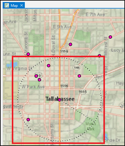
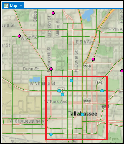
In ArcGIS Pro, features on a map can be interactively selected for data analysis, but in some cases, attempting to select the features fail. The map below demonstrates schools around Tallahassee, Florida are not highlighted on the map when attempting to select the schools.
Cause
- The layer containing the features is disabled for selection.
- The layer containing the features is invisible due to the visibility range limits.
- The 'Selection combination mode' option does not enable the creation of a new set of selected features.
Solution or Workaround
Depending on the cause, follow one of the workarounds below to resolve the issue.
Note:
In ArcGIS Pro, open the project containing the layer with the features for selection before proceeding with any of the workarounds provided. Refer to ArcGIS Pro: Open a project for more information.
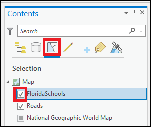
Enable the layer for selection
In the Contents pane, click the List By Selection icon, and check the check box for the layer containing the features.
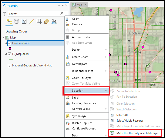
Ensure the layer is the only selectable layer
- In the Contents pane, right-click the layer.
- Hover the pointer over Selection, and click Make this the only selectable layer.
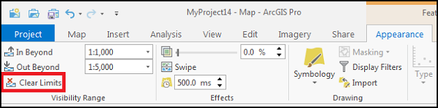
Clear the visibility range limits to enable the layer to draw at all zoom levels
- In the Contents pane, click the layer's name.
- On the ribbon, click the Appearance tab.
- In the Visibility Range group, click Clear Limits.
Set the Selection combination mode to enable selecting a new set of features
- On the ribbon, click the Project tab, and click Options.
- In the Options window, click Selection.
- Under Selection Combination Mode, select Create a new selection.
- Click OK.
The image below shows the schools around Tallahassee highlighted in the selected color, cyan, after enabling the layer for selection.
Note:
The color can be set according to preference. Refer to ArcGIS Pro: Selection options for more information.
Article ID: 000025341
- ArcGIS Pro 2 7 x
- ArcGIS Pro 2 x
Get support with AI
Resolve your issue quickly with the Esri Support AI Chatbot.


Related Information
Discover more on this topic
Search for related information
Find training related to this topic
Explore ideas and give feedback
Get help from ArcGIS experts
Start chatting now