A to Z GIS | Explore this related guide, featuring updated terms and graphics and developed in coordination with Esri’s GIS Dictionary team.
Learn more about A to Z GIS
GIS Dictionary
Browse dictionary
union
URL copiedShare URL
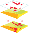
[data conversion, spatial analysis]
The overlay of two or more spatial polygon datasets that preserves the features that fall within the spatial extent of either input dataset. In a union, all features from both datasets are retained and extracted into a new polygon dataset.