A to Z GIS | Explore this related guide, featuring updated terms and graphics and developed in coordination with Esri’s GIS Dictionary team.
Learn more about A to Z GIS
GIS Dictionary
Browse dictionary
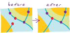
snapping
URL copiedShare URL
[spatial analysis]
The process of moving a feature to match or coincide exactly with another point or feature's coordinates. Commonly used to increase accuracy. Snapping may also be used to adjust the extent of the cells in one raster to match the extent of the cells in another raster.