A to Z GIS | Explore this related guide, featuring updated terms and graphics and developed in coordination with Esri’s GIS Dictionary team.
Learn more about A to Z GIS
GIS Dictionary
Browse dictionary
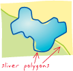
sliver polygon
URL copiedShare URL
[data conversion, geometry]
A small, narrow, polygon feature that appears along the borders of polygons following the overlay of two or more geographic datasets. Sliver polygons may indicate topology problems with the source polygon features, or they may be a legitimate result of the overlay.