A to Z GIS | Explore this related guide, featuring updated terms and graphics and developed in coordination with Esri’s GIS Dictionary team.
Learn more about A to Z GIS
GIS Dictionary
Browse dictionary
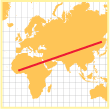
rhumb line
URL copiedShare URL
[geodesy, geometry]
A complex curve on the earth's surface that crosses every meridian at the same oblique angle. A rhumb line path follows a single compass bearing; it is a straight line on a Mercator projection, or a logarithmic spiral on a polar projection. A rhumb line is not the shortest distance between two points on a sphere.