A to Z GIS | Explore this related guide, featuring updated terms and graphics and developed in coordination with Esri’s GIS Dictionary team.
Learn more about A to Z GIS
GIS Dictionary
Browse dictionary
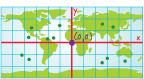
projected coordinates
URL copiedShare URL
[measurement, coordinate systems]
A measurement of locations on the earth's surface expressed in a two-dimensional system that locates features based on their distance from an origin (0,0) along two axes, a horizontal x-axis representing east–west and a vertical y-axis representing north–south. Projected coordinates are converted from latitude and longitude to x,y coordinates using a map projection.