A to Z GIS | Explore this related guide, featuring updated terms and graphics and developed in coordination with Esri’s GIS Dictionary team.
Learn more about A to Z GIS
GIS Dictionary
Browse dictionary
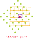
nearest neighbor resampling
URL copiedShare URL
[spatial analysis]
A technique for resampling raster data in which the value of each cell in an output raster is calculated using the value of the nearest cell in an input raster. Nearest neighbor assignment does not change any of the values of cells from the input layer; for this reason, it is often used to resample categorical or integer data (for example, land use, soil, or forest type), or radiometric values, such as those from remotely sensed images.