A to Z GIS | Explore this related guide, featuring updated terms and graphics and developed in coordination with Esri’s GIS Dictionary team.
Learn more about A to Z GIS
GIS Dictionary
Browse dictionary
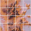
mosaic
URL copiedShare URL
[image processing]
A raster dataset composed of two or more merged raster datasets—for example, one image created by merging several individual images or photographs of adjacent areas.
[map design]
Maps of adjacent areas with the same spatial reference and scale whose boundaries have been matched and dissolved.
[visualization techniques]
When discussing photos or images, an image composed of multiple individual photographs or images of adjacent areas merged into a single photograph or image without gaps. For photographs, it is called a photomosaic, and for images, it is called an image mosaic. When discussing landscapes, the entire set of landscape patches that cover a region.