A to Z GIS | Explore this related guide, featuring updated terms and graphics and developed in coordination with Esri’s GIS Dictionary team.
Learn more about A to Z GIS
GIS Dictionary
Browse dictionary
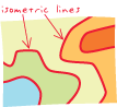
isometric line
URL copiedShare URL
[symbology]
An isoline drawn according to known values, either sampled or derived, that can occur at points. Examples of sampled quantities that can occur at points are elevation above sea level, an actual temperature, or an actual depth of precipitation. Examples of derived values that can occur at points are the average of temperature over time for one point or the ratio of smoggy days to clear days for one point. Often used interchangeably with isarithm.