Sticky Dialog Bar | Support | GIS Dictionary

A to Z GIS | Explore this related guide, featuring updated terms and graphics and developed in coordination with Esri’s GIS Dictionary team.

Learn more about A to Z GIS

GIS Dictionary

Browse dictionary

inverse distance weighted interpolation

URL copied Share URL
  1. [mathematics] 
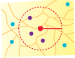
An interpolation technique that estimates cell values in a raster from a set of sample points that have been weighted so that the farther a sampled point is from the cell being evaluated, the less weight it has in the calculation of the cell's value. Media/inverse-distance-weighted.gif

See also