A to Z GIS | Explore this related guide, featuring updated terms and graphics and developed in coordination with Esri’s GIS Dictionary team.
Learn more about A to Z GIS
GIS Dictionary
Browse dictionary
edge
URL copiedShare URL
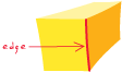
[geometry]
A line between two points that forms a boundary. In a geometric shape, an edge forms the boundary between two faces. In an image, edges separate areas of different tones or colors. In topology, an edge defines lines or polygon boundaries.
[network analysis]
In a network system, a line feature through which a substance, resource, or traffic flows. Examples include a street in a transportation network and a pipeline in a sewer system.
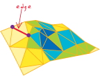
[geometry, spatial analysis]
In a TIN data model, a line segment between nodes (sample data points). Edges store topologic information about the faces that they border.