A to Z GIS | Explore this related guide, featuring updated terms and graphics and developed in coordination with Esri’s GIS Dictionary team.
Learn more about A to Z GIS
GIS Dictionary
Browse dictionary
dissolve
URL copiedShare URL
[visualization techniques]
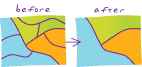
A geoprocess that removes boundaries between adjacent polygons that have the same value for a specified attribute.
[spatial analysis]
The process of removing unnecessary boundaries between features, such as the edges of adjacent map sheets, after data has been captured.