A to Z GIS | Explore this related guide, featuring updated terms and graphics and developed in coordination with Esri’s GIS Dictionary team.
Learn more about A to Z GIS
GIS Dictionary
Browse dictionary
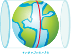
cylindrical projection
URL copiedShare URL
[map projections]
A map projection that transforms points from a spheroid or sphere onto a tangent or secant cylinder; similar to wrapping a piece of paper around a globe. Meridians (lines of longitude) and parallels (lines of latitude) are projected as straight lines that intersect at right angles on the map. Distance, shapes, and area become increasingly distorted as one moves away from the origin.