A to Z GIS | Explore this related guide, featuring updated terms and graphics and developed in coordination with Esri’s GIS Dictionary team.
Learn more about A to Z GIS
GIS Dictionary
Browse dictionary
centroid
URL copiedShare URL
[spatial analysis, geometry]
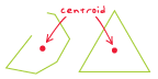
The geometric center or average location of a spatial feature. For line, polygon, or three-dimensional features, it is the center of mass (or center of gravity) and may fall inside the feature, as shown in the example image for a triangle, or outside the feature, as shown in the example image for a complex line. For multipoints, polylines, or polygons with multiple parts, it is computed using the weighted mean center of all feature parts.
[geodesy]
The center of area; the balance point or center of gravity.