A to Z GIS | Explore this related guide, featuring updated terms and graphics and developed in coordination with Esri’s GIS Dictionary team.
Learn more about A to Z GIS
GIS Dictionary
Browse dictionary
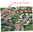
centerline
URL copiedShare URL
[image processing, geometry]
A line digitized along the center of a linear geographic feature, such as a street or a river, that at a large enough scale would be represented by a polygon.
[navigation]
The center of the street designated by the painted line down the center of the street or interpolated from the pavement edges.