A to Z GIS | Explore this related guide, featuring updated terms and graphics and developed in coordination with Esri’s GIS Dictionary team.
Learn more about A to Z GIS
GIS Dictionary
Browse dictionary
cell
URL copiedShare URL
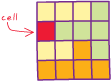
[data architecture]
The smallest unit of information in raster data, usually square in shape. In a map or GIS dataset, each cell represents a portion of the earth, such as a square meter or square mile, and usually has an attribute value associated with it, such as soil type or vegetation class.
[image processing]
A pixel.
[symbology]
A small drawing, usually of a frequently used or complex symbol, notation, or detail. Cells are similar to blocks in AutoCAD drawings.