A to Z GIS | Explore this related guide, featuring updated terms and graphics and developed in coordination with Esri’s GIS Dictionary team.
Learn more about A to Z GIS
GIS Dictionary
Browse dictionary
baseline
URL copiedShare URL
[surveying, measurement]
An accurately surveyed line from which other lines or the angles between them are measured.
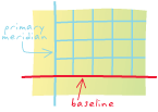
[surveying, standards, geodesy]
The parallel determined by government land surveyors that intersects the principal meridian to establish an initial point in the U.S. Public Land Survey System and Canada's Dominion Land Survey. Also called a geographer's line.
[remote sensing, measurement]
In GPS, the physical distance between a base station and a rover.