A to Z GIS | Explore this related guide, featuring updated terms and graphics and developed in coordination with Esri’s GIS Dictionary team.
Learn more about A to Z GIS
GIS Dictionary
Browse dictionary
azimuth
URL copiedShare URL
[measurement, geodesy]
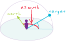
A direction measured in degrees clockwise from north starting at a given point, from 0 to 359.9. Azimuth may also be the direction from which a light source illuminates a surface.
[navigation, measurement]
In navigation, the horizontal angle, measured in degrees, between a reference line drawn from a point and another line drawn from the same point to a point on the celestial sphere. Normally, the reference line points true north, and the angle is measured clockwise from the reference line.
[remote sensing, measurement]
In satellite image collection, the direction the sensor is pointing, measured in degrees, which varies from 0° to 360°, starting with north at 0°.