A to Z GIS | Explore this related guide, featuring updated terms and graphics and developed in coordination with Esri’s GIS Dictionary team.
Learn more about A to Z GIS
GIS Dictionary
Browse dictionary
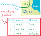
attribute table
URL copiedShare URL
[data architecture]
A database or tabular file containing information about a set of geographic features, usually arranged so that each row represents a feature, and each column represents one feature attribute. In raster datasets, each row of an attribute table corresponds to a certain zone of cells having the same value. In a GIS, attribute tables are often joined or related to spatial data layers, and the attribute values they contain can be used to find, query, and symbolize features or raster cells.