A to Z GIS | Explore this related guide, featuring updated terms and graphics and developed in coordination with Esri’s GIS Dictionary team.
Learn more about A to Z GIS
GIS Dictionary
Browse dictionary
aspect
URL copiedShare URL
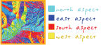
[measurement, geodesy]
The compass direction that a topographic slope faces, usually measured in degrees from north. Aspect can be generated from continuous elevation surfaces. For example, the aspect recorded for a TIN face is the steepest downslope direction of the face, and the aspect of a cell in a raster is the steepest downslope direction of a plane defined by the cell and its eight surrounding neighbors.
Can also be stated as the downslope direction of the maximum vertical change in the surface determined over a given horizontal distance.
[map projections]
The conceptual center of a projection system.
[geodesy]
The location of the point or lines of tangency on a developable surface.