A to Z GIS | Explore this related guide, featuring updated terms and graphics and developed in coordination with Esri’s GIS Dictionary team.
Learn more about A to Z GIS
GIS Dictionary
Browse dictionary
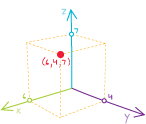
x,y,z coordinates
URL copiedShare URL
[geodesy, geometry]
In a planar coordinate system, three coordinates that locate a point by its distance from an origin (0,0,0) where three orthogonal axes cross. Usually, the x-coordinate is measured along the east–west axis, the y-coordinate is measured along the north–south axis, and the z-coordinate measures height or elevation.